NASA released photos of parts of Dubai and Abu Dhabi before and after the United Arab Emirates was hit by record rainfall last week that caused dangerous floods and paralyzed much of the country.
The images, taken by the NASA Earth Observatory on Friday using Landsat data from the U.S. Geological Survey, show large patches of water all over the desert and urban landscape of the UAE where previously there was none – almost looking as if small lakes had appeared.
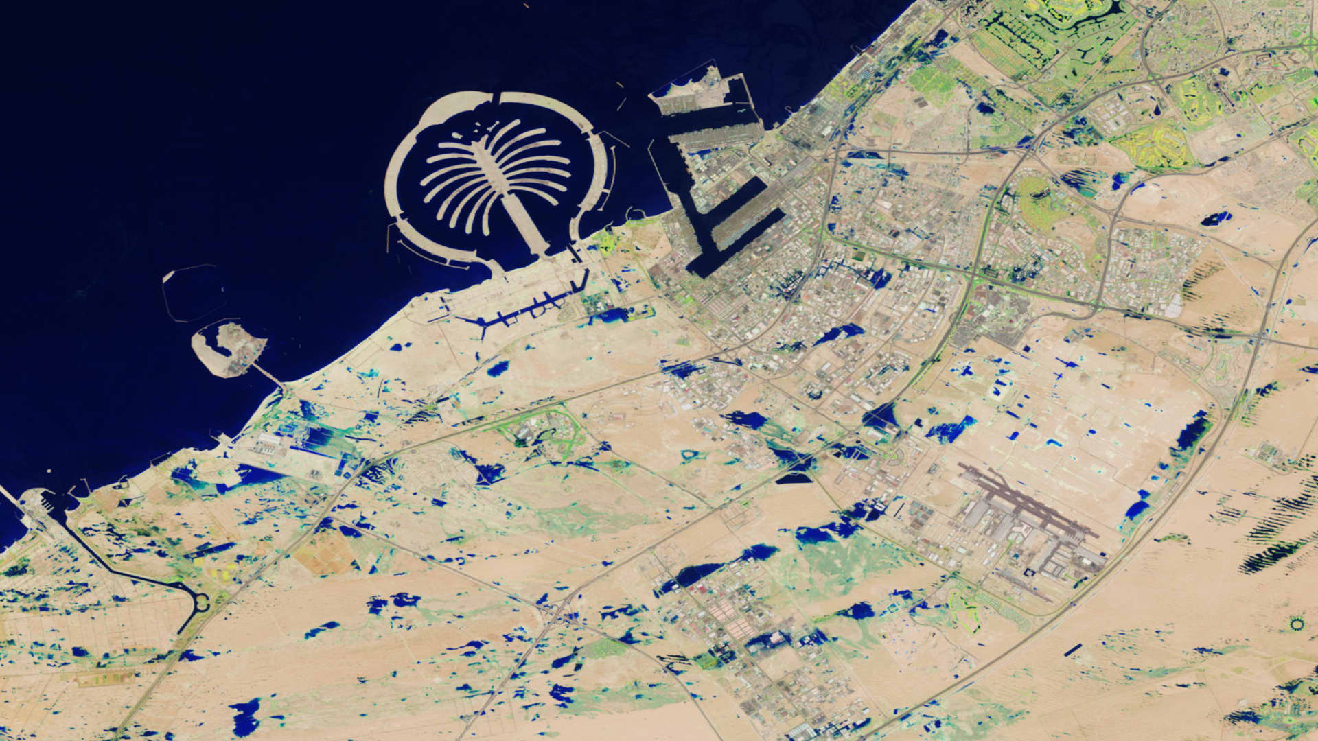
“Some areas remained flooded on April 19, when Landsat 9 passed over the region for the first time since the storms,” NASA wrote on its Earth Observatory website.
Flash floods that formed on April 16 led to water engulfing cars, in some areas fully submerging them, leading hundreds of drivers to abandon their vehicles on roads to escape the rising water levels.
The normally dry desert country in the Gulf was pummeled with roughly a year’s worth of rain in less than a day, more than it has ever seen in a single storm since records for the UAE began in 1949.
The first image from NASA shows part of Dubai and the surrounding area on April 3, taken by Landsat 9, an Earth observation satellite operated by a partnership between the U.S. Geological Survey and NASA. The second was taken on April 19, as Landsat 9 passed over the region for the first time since the record rainstorms hit the country.
The second image, acquired with the satellite’s OLI-2 (Operational Land Imager 2), “shows flooding in numerous parts of the emirate. The image is false color (bands 6-5-3) to emphasize the presence of water, which appears blue,” NASA wrote.
The deluge closed schools and businesses, grounded hundreds of flights, and destroyed cars, businesses and other property. It threw daily life into chaos as many residents lost power and running water or were trapped either inside their homes or in airports, or wherever they happened to be when the storm hit.
The UAE’s National Center of Meteorology said that eastern parts of the country measured up to 250 millimeters — 10 inches — of rain in less than 24 hours. By contrast, in a full year the UAE typically sees 5.5 to 8 inches of rainfall per year.
Due to a lack of drainage infrastructure and the fact that the country’s urban spaces are paved over, much of the water had nowhere to go, exacerbating the flooding in many areas.
The country’s cleanup efforts are ongoing, and numerous problems still remain in some areas where infrastructure has been severely damaged and many residents say they still don’t have running water or electricity.
One multistory apartment building near the border of Dubai and the emirate of Sharjah has cracked and tilted over due to structural damage from the storm, and was fully evacuated on Friday because it is in danger of collapsing.
The UAE’s central bank has issued a directive to local banks and insurance companies to allow loan repayment deferrals of six months, in an effort to help flood-hit residents and businesses.